This is a sample scrolling text that has scrolls in the upper direction.
Our Deepest Discount Of The Year Is Active!
Use code: 50off for 50% off your entire order.
Create A Permit-Ready Site Plan
in Just 3 Minutes.
America’s fastest, most affordable way for contractors and homeowners to create permit-ready site plans in as little as 3 minutes.
Get it Done Fast. Get it Done Right. With Unlimited Free Revisions.
Save Time
Cut Costs

Easy-To-Use

National Reach

The Numbers Speak For Themselves.
180 Sec
Save 75%
5 Simple Steps
Nationwide Data, Backed by Automation.
Nationwide Data, Backed by Automation.
Perfect for Residential & Commercial Projects.
Perfect for Residential & Commercial Projects.
No Training Required.
No Training Required.
What Our Customers Say.
A Game-Changer for My Projects
Very Practical & User-Friendly
Saved Me Time and Money
Simple Yet Powerful
Makes Site Planning Stress-Free
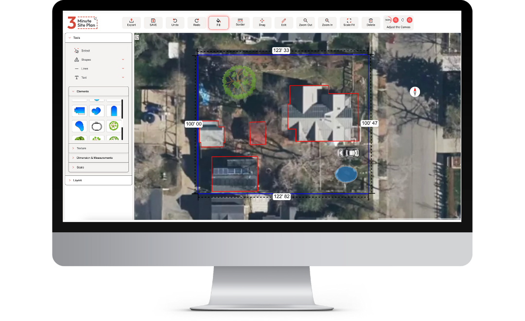
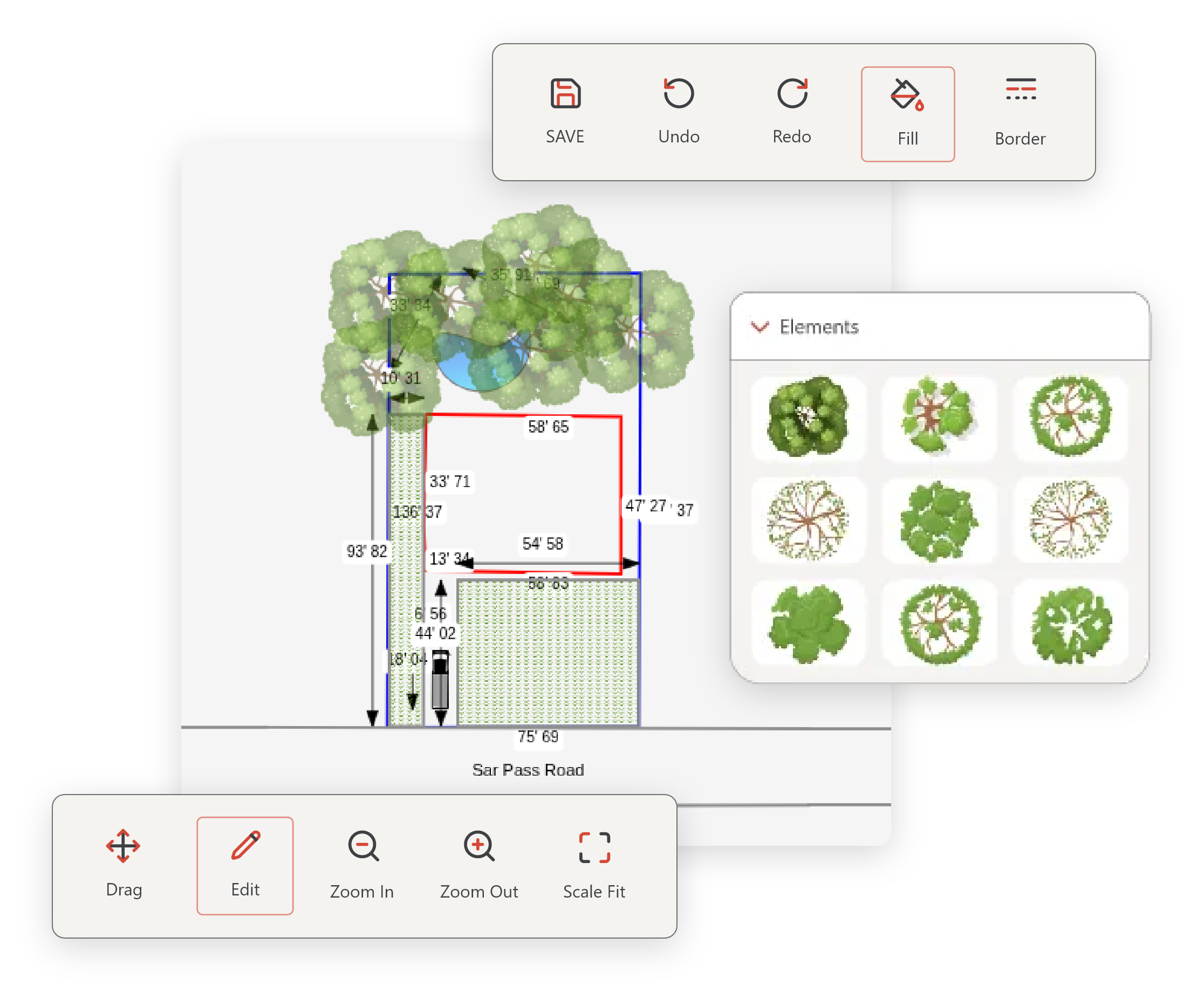
Powerful Features That Make DIY Site Plans Simple.
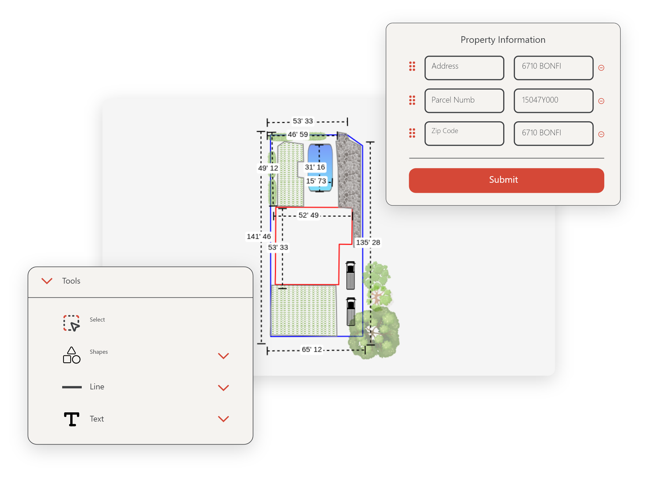
Address Lookup
Enter any US address and instantly access accurate property data for your site plan.
Satellite Imagery
Start with aerial views that eliminate the need for costly, time-consuming site visits.
Property Boundaries & Footprints
Automatically populate your plan with property lines and building footprints from official GIS data.
Drag-and-Drop Interface
Customize your site plan with intuitive controls—no technical skills required.
Precise Measurements
Add accurate dimensions and easily adjust the scale to match specific project requirements.
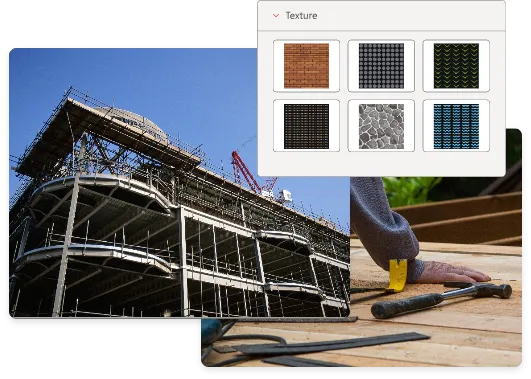
Elements Library
Access a massive collection of symbols, textures, and patterns for trees, structures, and more.
Custom Property Features
Easily add decks, pools, fences, and other planned additions to visualize your complete project.
Annotation Tools
Add notes, labels, and markups to clearly communicate your project details.
Permit-Ready Exports
Download your site plan in formats that meet permit and HOA requirements for easy submission.
Unlimited Revisions
Make changes anytime for free—your plans stay editable forever.
No CAD Experience Needed
Create professional-quality site plans without the complexity of traditional drafting software.
24/7 Support Resources
Get help when you need it with our comprehensive library of tutorials, guides, and FAQs.
Get Started Now.


Site Plans for Every Project.
Fences & Decks
Sheds & Outbuildings
Pools & Spas
Tree Removal
Retaining Walls & Hardscaping
Construction Permits
Frequently Asked Questions
How accurate are the property boundaries?
The geographic information and data presented here are for general reference only and are not guaranteed to be accurate, complete, or current. All spatial data are derived from public and private sources believed to be reliable; however, positional accuracy may vary depending on the source, scale, and date of acquisition.
This map and associated data are not intended for use in legal, engineering, or surveying purposes. Boundaries, parcel lines, and other geographic features are approximate and should not be relied upon as exact locations. Users are responsible for verifying all information independently before making decisions based on this data.
Will my site plan be accepted by my local permit office/HOA?
Every city, county, and HOA has its own specific requirements for what must be included in a site plan. The 3 Minute Site Plan tool gives you the ability to create professional-looking site plans quickly and accurately, but you are responsible for ensuring that your plan meets your local requirements.
In many cases, plans created with our tool are accepted for building permits, planning applications, and HOA reviews — especially for residential projects like sheds, fences, driveways, patios, and small additions.
However, some jurisdictions or HOAs may require plans prepared or stamped by a licensed professional (such as a surveyor, engineer, or architect). We recommend checking your local requirements before submission.
Your plan’s accuracy will depend on the quality of the information you provide (measurements, parcel data, etc.), so always double-check details before submitting.
Do I need any special software to use 3-Minute Site Plan?
No—you don’t need to install any special desktop CAD software to use 3-Minute Site Plan. The tool runs in your web browser and is designed so anyone can create a site plan without prior drafting experience.
You simply:
Enter your property address to auto-populate lot lines, building footprints, satellite imagery and GIS data.
Use the drag-and-drop interface to place structures, fences, pools, annotate, set scale, etc.
Export your plan (PDF or image) ready for permit submission or HOA review.
Does 3-Minute Site Plan work on mobile phones or tablets?
3-Minute Site Plan is currently designed for desktop and laptop computers only. Because the tool uses advanced mapping, scaling, and drag-and-drop features, it requires the precision and screen size of a desktop interface to work properly.
You can still view your finished plans or check your account from a mobile device, but to create or edit plans, please use a computer with a mouse or trackpad for the best experience.
How long do my credits last?
Credits don’t ever expire.