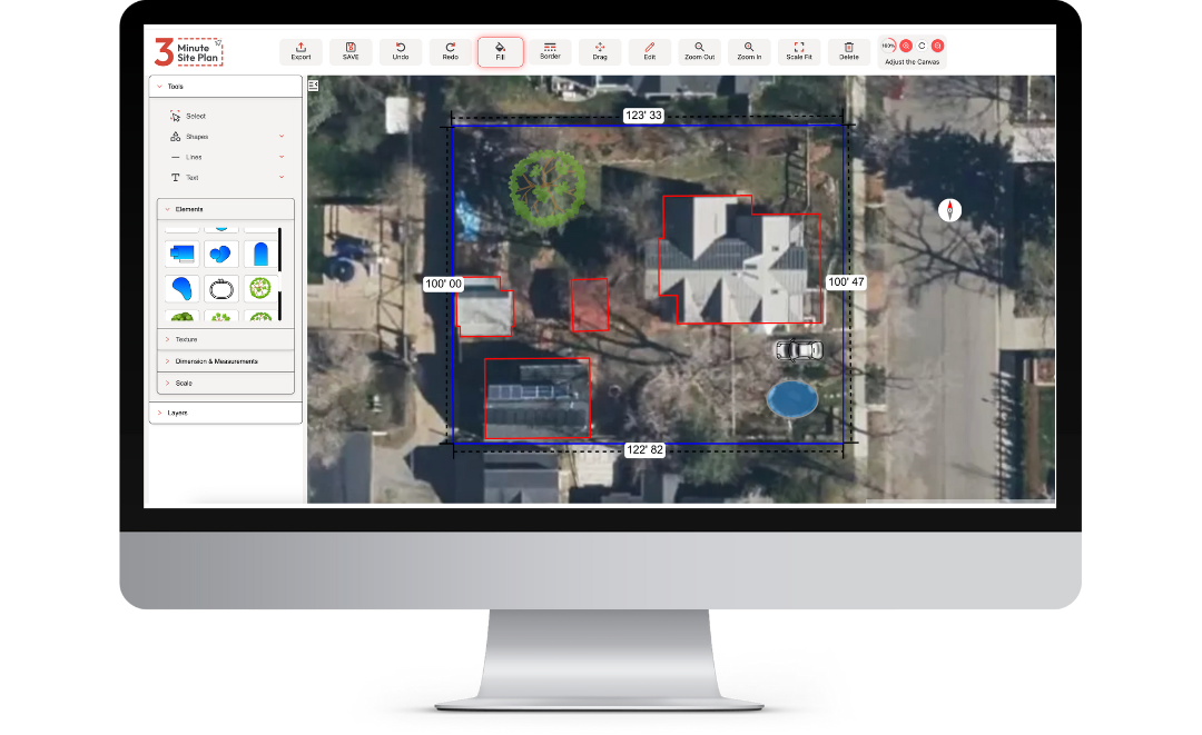
3-Minute Site Plan uses publicly available GIS (Geographic Information System) and parcel data to display property boundaries. These boundaries are typically accurate enough for planning, visualization, and most permitting purposes. However, because the data is sourced from local and county databases—which can vary in precision—it should not be considered a legal survey.
In most cases, the boundary lines are within a few feet of the true property limits, making them perfectly suitable for general site planning, project layouts, and communicating design intent. If you need exact boundary verification for construction or legal disputes, you should consult a licensed land surveyor.
Will my site plan be accepted by my local permit office/HOA?
In most cases, yes. Many users successfully use 3-Minute Site Plan drawings for permit and HOA submissions across the country. The plans are drawn to scale, include property boundaries and measurements, and clearly show the placement of proposed improvements such as pools, sheds, driveways, or ADUs—meeting the basic requirements most agencies ask for.
However, acceptance ultimately depends on your local jurisdiction or HOA’s specific standards. Some offices may require a certified or engineered plan prepared by a licensed professional. If that’s the case, your 3-Minute Site Plan can still serve as a valuable reference or preliminary layout to provide your designer, contractor, or surveyor.
In short: Many cities and HOAs accept 3-Minute Site Plan drawings for permit applications, but you should always check local requirements to confirm whether a certified plan is needed.
Do I need any special software to use 3-Minute Site Plan?
No, you don’t. 3-Minute Site Plan is designed to run fully in your web browser — there’s no need to install desktop CAD software. Site Plan Software+1
Here are a few extra details and caveats to make the answer robust for your users:
You simply log into the platform online, enter your property address, and the system auto-loads parcel boundaries, aerial imagery and GIS data. Site Plan Software+1
The drag-and-drop interface is browser-based, so the major requirement is just a reasonably up-to-date computer and a supported browser. Site Plan Software
The platform currently works best on a desktop or laptop, rather than giving full editing functionality on mobile phones or tablets. (You may be able to view plans on mobile, but creating or editing is optimized for larger screens and pointer input.) Site Plan Software
Because there is no specialized software installation, there’s lower barrier to entry — which is in line with the “DIY friendly” positioning of the tool.
Does 3-Minute Site Plan work on mobile phones or tablets?
Not fully. The platform is designed primarily for desktop and laptop use (with a full mouse/trackpad and larger screen) for creating and editing site plans. Site Plan Software You can view your completed plans or check your account on a mobile phone or tablet, but key editing and design functions (drag-and-drop, accurate scaling, map adjustment) are best done on a computer.